
Features Beaver ATV Trails
Lifetime Map, no annual Fee, no in-app purchases.
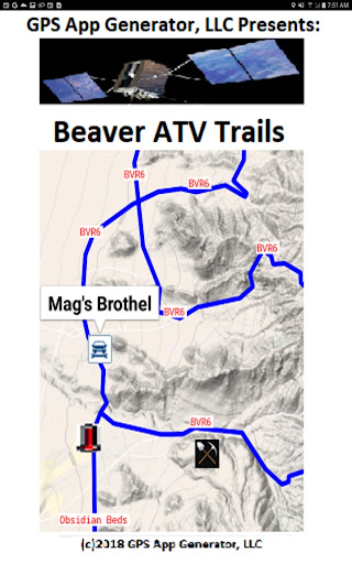
Beaver ATV Trails.
Beaver Utah has many mines, steam vents, obsidian, a ghost town, an old brothel, and many more interesting things to discover.
There are in excess of 944 miles of Trails mapped.
If you are traveling, it has at least 6 hotels.
The folks there are big on riding ATVs, so you will be among friends.
They have an ATV Jamboree, usually in May, much like Panguitch, Paiute and Kanab, for example.
There are several National Parks within driving distance also.
Get this App and you will be less likely to get lost.
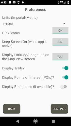
It shows you where you are in relation to the Trails, using your Android Phone or a Tablet if it has a real GPS.
The App does not rely Cell Towers or WiFi, it uses your phones GPS.
That way you can stay on provided trails and not get lost or make new trails where they are not wanted.
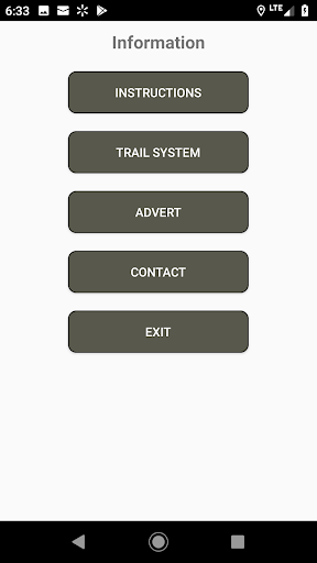
Points of Interest are marked, and, like the Trail Numbers, one touch tells you the name of the Trail or Point of Interest.Beaver hosts Beaver County Trails ATV/UTV Jamboree every year in May.I added a new feature, North Up (2D, default) or Direction of Travel up (3D), like in most dashboard GPSs.
I think 3D is better.Also, you can go to the Find List and select My Location and a thing you want to see or get to, and tick those, and go to Find View map and see where it is, compared to where you are.
Then you can note the trails in between, go back to the List and tick My Location, the POI, and the Trails in between, and see on the Find View map the path from where you are to the Point of Interest highlighted in Yellow.
A rudimentary GPS navigation tool.
Fitness Tracking
Track your workouts and monitor your health metrics.
Travel Features
Plan and manage your travels with ease.
Food & Dining
Discover recipes and order food from your favorite restaurants.
See the Beaver ATV Trails in Action
Get the App Today
Available for Android 8.0 and above